Starting from version 5.7.0 (Published on 13-06-2015) new “Geoid Height” extension allows to record altitude as orthometric height (height above EGM96 geoid which approximates mean sea level).
The extension is paid and can be enabled in “Measurement Settings”.
The Geoid is a model of the Earth’s surface that represents the mean global sea level. Its shape passes through the Earth’s crust and is determined from data collected all over the world about the Earth’s gravity field. The vertical distance between the geoid and the ellipsoid is called the geoid height. This height can be either negative of positive. Differences in height between the geoid and ellipsoid (geoid heights) range from roughly -100 to +100 meters.
If you would like to record the orthometric height instead of the ellipsoidal GPS height which assumes the Earth to be totally homogeneous as if there be would no mountains or trenches this extension will do the job and no post processing is needed.
The picture below explains the differences between the ellipsoidal and orthometric height.
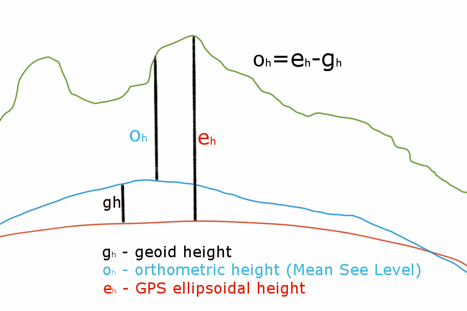
Orthometric height (Mean See Level)
The extension is using Worldwide 15 Minute Binary Geoid Height File to calculate the geoid offset.
You can check the difference between the WGS84 (GPS) altitude and the Mean See Level using the program on this website:
http://geographiclib.sourceforge.net/cgi-bin/GeoidEval?input=55.00+-3.00&option=Submit .
More information: http://www.esri.com/news/arcuser/0703/geoid1of3.html